What you see here is the profile-output of a relatively long route. And what can this tell me? If and where I will encounter hills! And I really love this app, because I can really plan my rides better if I know these factors. To be able to see where these hills actually appear, you can of course see the path on the map (I cannot embed a map into this blog, because for some reason, google maps does not allow this when using path profiler). A little tip is to click the "follow roads" button, which allows you to select fewer waypoints and still get an accurate output.
Sunday, June 8, 2008
The value of Google Maps for cyclists
I've run over a little feature on maps.google.com that has proven to be extremely valuable for me as a bicycle rider. Ok, you're planning to go for a spin, and the area is not 100% familiar to you, how do you know if you have chosen a downhill run, or if the day is going to get filled with uphills? The simple solution to this is a genius tool called Path-Profiler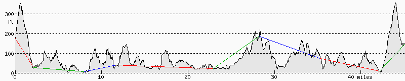
Subscribe to:
Post Comments (Atom)

No comments:
Post a Comment